|
|
|
|
|

Each year the Saltville Foundation sponsors paleontological and archeological research in the Saltville area, most specifically the wellfields area. In past years many significant findings have been documented.
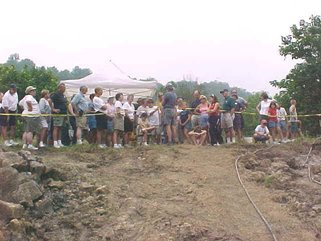
Volunteers are able to enroll to assist in the digs each summer. If you are interested in participating in a dig, please contact the museum for an application.
![]()
2002 Summer Dig Yields a "Mammoth" Find
The second week of the summer paleontological field season, sponsored by MoMA, yielded a "mammoth" amount of vertebrate fossil remains. In fact, Dr. Ralph Eshelman, who directed the excavation, reports that the site, SV10, yielded the most remains recovered during any known week of excavations within the Saltville well fields. "As far as we can tell, this is the most complete elephant to be found in Saltville," said Eshelman.
Dr. Eshelman's report follows.
Saltville Valley Paleontological Field Season
July 29 - August 9, 2002
Summary Results
Objectives: The purpose of the 2002 field season was 1) to test for possible paleontological remains at one or more new sites within the Saltville well fields; 2) to expand our knowledge of the Pleistocene stratigraphy of the Saltville valley; 3) to provide a research/educational venue for the museum; and 4) to provide possible specimens for the museum's research and exhibition collections.
Site Location and Preparation: An excavation pit was mechanically dug by backhoe at a site located on the south side of the drainage ditch, north side of Lake Drive, east of SV1 and west of the lake, nearly due north of the Saltville Coon Club. This site was designated SV9. At the end of the first week, with little promise from this site, a second dig site was investigated.
Several test pits were opened by backhoe. Based on oral communication with Jim Call, a former well field worker who operated a dozer during the construction of the irrigation ditch in the late 1950s/early 1960s, two test pits were opened near the northwest side of the culvert under Lake Drive northwest from the town shop. Nothing promising was discovered here though Mr. Call remembered pushing a large bone up out of the mud near here. Mr Call remembered that most of the bone uncovered during the digging of the ditch were found between SV1 and the above mentioned culvert.
Two additional test pits were opened further to the east where an old road crossed the well field on the west side of Pond II. This area was chosen based on oral communication with Bob Austin who as a boy remembered seeing large gone sticking out of a shallow hole in this area. The test pit closest to Lake Drive yielded a fish and turtle bone. The stratigraphy looked very promising with clam and snail material present in W3. The "10,000" year organic zone was prominent and the general stratigraphy of the site similar to SV1 and 2. However, due to rapid water intrusion into the pit it was decided not to excavate this site this year.
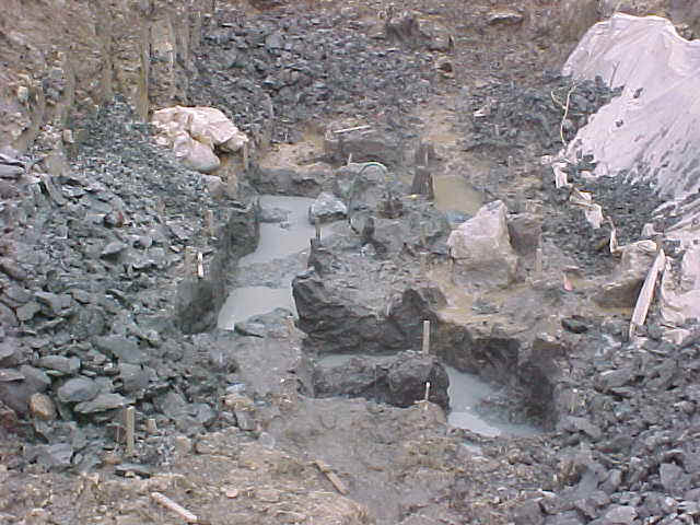
Several additional test pits were opened to the east of SV9 without any promising results. Finally, a test pit was opened on the north side of the ditch near SV5 and 6 but nearer to the northwest side of Pond II. As the backhoe reached near the lag gravel level a proboscidean vertebra was uncovered. As the site was enlarged several other proboscidean bones were uncovered despite the caution of making more shallow cuts. The site was designated SV10.
![]()
Following is a report of findings from the 2001 summer dig.
Summer Dig 2001
According to Dr. Ralph Eshelman, field director for the summer dig, the purpose of the 2001 field season was 1) to test for possible paleontological and archeological remains at the future Virginia Gas Company brine recrystalization plant site; 2) expand knowledge of the Pleistocene stratigraphy of the Saltville valley; 3) provide a research/educational venue for the museum; and 4) provide possible specimens for the museum's collections. This was a onetime opportunity to test this section of the well fields.
Paleontological Results
While the site, SV8, was not nearly as fossiliferous as some previous sites, significant remains were recovered including: two proboscidian vertevrae, a musk ox tooth, a deer-sized calcanium, one complete lower jaw of muskrat (Ondatra), unidentified frog and fish material, gastropod and bivalve specimens including a snail believed to be new to the fauna, two insect remains, and numerous plant specimens.
The stratigraphy of SV8 was different from any other section thus far examined. The differences suggest SV8 represents a site somewhat distant from the main Salt River paleo-channel, possibly an oxbow or small feeder stream with abundant vegetation.
Due to the depth of the excavation pit - approximately 18 feet below the surface - rain was a special problem as flooding was encountered from two different rain events. A weekend rain caused the pit to flood nearly 8 feet.
Archaeological Results
An archaeological survey during the third week was conducted by Dr. Cliff Boyd, Radford University. Dr. Boyd reports that the goal of the survey was to identify any historically or culturally significant sites or properties that would be impacted by the construction of a warehouse facility. A datum was established for mapping purposes and a grid was laid out over most of the area. Shovel test pits were then excavated at each of the grid points and excavated soils were dry screened for the systematic recovery of small artifacts. A total of 33 shovel tests was excavated. Due to downed trees and thick vegetation in some areas, shovel tests could not be excavated, so a split-spoon soil coring probe was used to examine stratigraphy and to check for buried cultural deposits. A steep hill slope was examined by a walkover survey.
The survey of the future location of a Virginia Salt Company facility produced artifacts in only one location - around an abandoned salt well head and road bed. The condition of the artifacts indicated that they were secondarily deposited. It was concluded that the construction of a facility in the area would not adversely impact any historic or cultural features or deposits that are eligible for listing on the National Register of Historic Places.